OK, so I may be a self-confessed geography nerd. It’s not my fault: I was a Hydrographic Surveyor with the Royal Navy and then I spent a further ten years of my career at Ordnance Survey where they had the tag line “everything happens somewhere”. And indeed, it does.
So, what’s the relevance of this to a local authority struggling to maximise revenue from the collection of council tax and business rates?
Geography, or rather geographic information systems (GIS), can be used across local authorities in multiple departments to support planning and inform decision making. Ordnance Survey mapping data that is integral to your council’s GIS activity is supplied, free of charge, under the Public Sector Geospatial Agreement (a ten year contract that commenced 01st April 2020).
Why is this interesting?
Well, geography can be used to rationalise special education needs transport requirements – ensuring that the most effective and cost efficient routes are taken on a daily basis.
Geography can support emergency planners – locating the most vulnerable citizens whenever there is an environmental threat.
Geography can inform winter gritting routes – ensuring the safe flow of traffic during inclement weather.
Geography is an aid to planning – where to position a new day care centre for adults with needs based upon the location of the care recipients and the local transport infrastructure.
Geography can be used to determine Ambulance “stand-by” locations – facilitating a speedy response to 999 calls and meeting Government response-time targets.
Geography can be used to keep children safe and healthy by ensuring no planning permissions for fast food restaurants are allowed within 500m of school gates.
And geography can be used to identify property, on the ground, from which the council is receiving neither Council Tax nor NNDR.
This is about collaborative working between different departments in a local authority – striving towards a common goal (in this case maximising revenue collection).
And it is quite simple to do: the resultant map will clearly support your Revenues Collection Team’s efforts.
- Find out where your council GIS specialist works. They are often found associated with the Planning function. If you don’t have anyone with GIS skills then you can work with your preferred contractor and the Ordnance Survey data will be covered by the Contractors’ Licence.
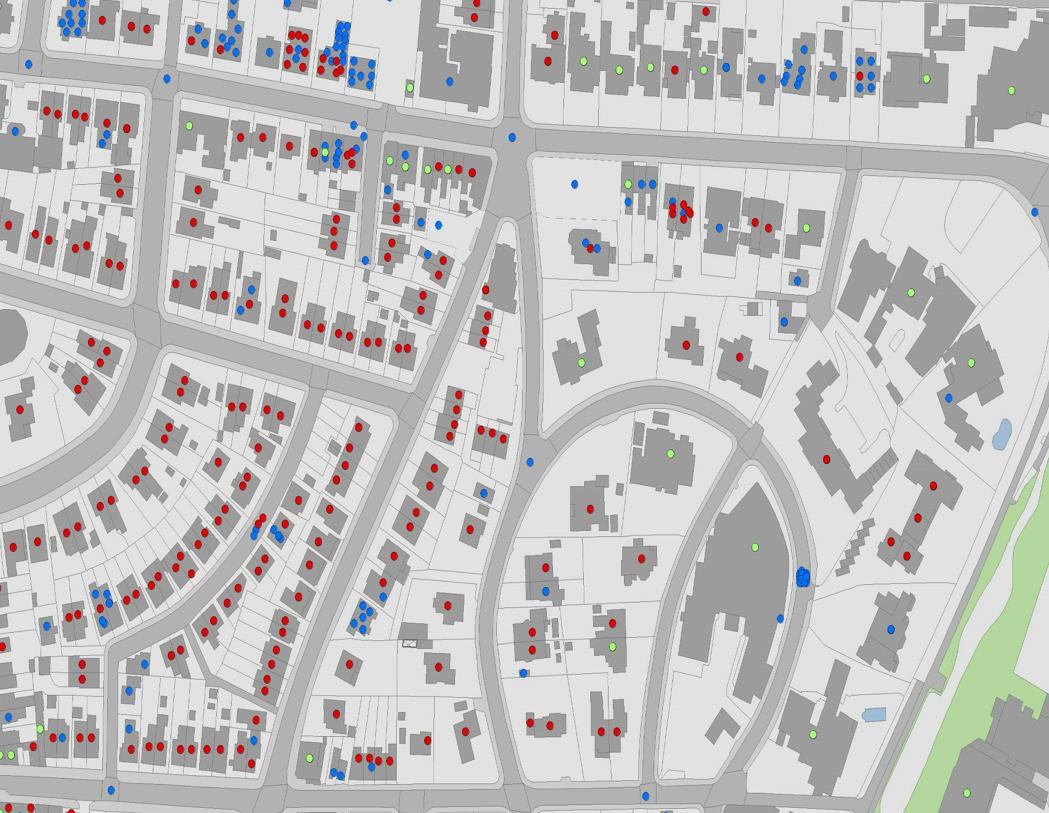
- Provide a copy of your Council Tax and NNDR records. Within the GIS, this data can be overlain on Ordnance Survey’s Master Map layer, colour-coded, so that you can clearly see properties on the ground from which you are receiving Council Tax (red dots on those buildings) and NNDR (perhaps blue dots).
- Move around the mapping in the GIS, looking for buildings within the Ordnance Survey Master Map layer that don’t have a blue or red dot – property from which the council is receiving neither Council Tax nor Business Rates. Some of these properties will be exempt (electricity sub-stations for example). But, some of these buildings should be included in the Council Tax or Business Rates database and should be generating Council Tax or Business Rates.
- Send out your site investigators (or ask Liberata to do this on your behalf, in combination with an Empty Homes, Single Person Discount or Business Rates Review perhaps)
And what’s more, this is quite fun to do – “driving” around the borough, using GIS, generating additional revenue and maximising the accuracy of your Council Tax and BBDR data.
Did I mention that I was a bit of a geography nerd?